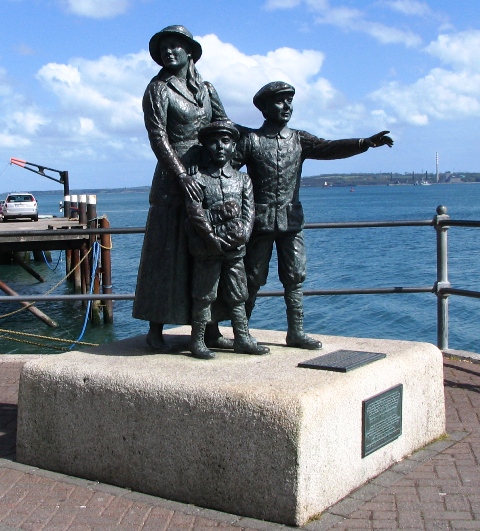
Click the Cobh Immigrant Memorial above to see an album of Southeast Ireland photos. Close the window to return to this page.
|
Ireland April 23 2007 – May 23 2007 More than a year ago Claudia and Neil Carver sent an email to several friends. “How about joining us next May in Ireland on the Beara peninsula for a week of hiking and good company.” Neil had taken the place of the Castletownbere Church of Ireland minister while he went of holidays. Neil and Claudia had explored many of the hiking trails that make up the eight-day Beara Way Trail. They had maps and were looking forward to introducing us to their favourite spots. Seven couples quickly signed up to go. The seven women had all graduated together from Bishop’s University in Lennoxville Quebec way back in the sixties and three of the husbands were graduates as well. It promised to be a good get-together. We stayed, as usual, in hostels whenever we could get a double room. They were economical, friendly, clean and comfortable and had the extra benefit of a communal kitchen. As much as we liked eating in the pubs, we like to save a little money by cooking our own meals. We have several quick and tasty favourites that can be enjoyed over a bottle of wine bought in the grocery store. We did stay in a few good Bed and Breakfasts but more than one big Irish breakfast a week is too much for us. Ireland isn’t called the Emerald Isle for nothing. The fields were new green, the leaves were out and the spring flowers were blooming when we arrived on April 24. This was in strict contrast to the brown, still barren Ottawa landscape we had left behind. Of course all that green comes with a price. It rains in Ireland, frequently, but when we were there, not all day. Ray and I had hoped that scheduling our trip for late April and May would mean heaps of good weather. Indeed, for the first time in forty years, the skies were blue in Ireland from late March until early May we enjoyed unseasonably good weather for the start of our trip, but it did not last. It didn’t really stop us from our activities. We just donned our rainwear on the less than perfect days and carried on. Ireland is even more dramatic in the wind and rain and the day never finished on a low note. We had some great hikes, the people couldn’t have been friendlier and accommodating, the drivers on the narrow roads were patient and polite and the traditional music in the pubs was superb. Five narrow peninsulas fan out into the Atlantic from the southwest coast of Ireland. The Beara Peninsula is in the middle, just south of the Ring of Kerry. We reserved two large four-bedroom Holiday Homes just outside Allihies, a small town at the tip of the Beara Peninsula for the week starting May 5, 2007. Ray and I had never visited Ireland before so we planned to explore more of the southern part of the country both before and after meeting up with the group. We flew from Ottawa to London Heathrow on April 23 on Air Canada and continued to Cork on Aer Lingus. We picked up our small rental car in Cork and drove to our hostel where we discovered that even seasoned travellers like our selves could make mistakes. We had switched luggage. Some poor unsuspecting man returning to London from Ottawa had the same bag as mine. We had not encountered many other blue MEC bags on our travels so we had become lax in reading name tags. I phoned Air Canada in London and they knew all about the bag switch. Luckily, even though Aer Lingus is not a partner with Air Canada, they agreed to ship the mistakenly taken bag back to London and to return my bag to Cork, without charge. It took more than two days but the bag arrived safe and sound. Next time my bag is again going to sport an orange ribbon to identify it and we are going to check name tags very carefully. An extra day in Cork allowed us to explore more of the town and its surroundings. Our hostel, Kinlay House, was right next to St Anne’s Church in Shandon. The church is topped by the “Four Faced Liar”, a clock tower with a golden salmon weather vane. The four faces of the clock never display quite the same time except when they come together at the hour. The bells are really the draw at St Anne’s. For a small fee, a visitor can play a tune on the eight bells. Ray called out the bell numbers marked on an instruction sheet for the popular “Bells of St Mary” while I pulled the ropes. I’m sure several neighbours got a laugh out of one more tourist’s attempts at a serenade, but it was fun. The port of Cobh, pronounced “Cove”, is 24 km from Cork. Tourists come to research their families using the databases available in the very informative Heritage Center and to see the displays on shipping. Cobh was the departure point for millions of Irish emigrants, especially during the mid-nineteenth century potato famine, on their way to Canada, USA and Australia. The Heritage Center tells the harrowing tales of passengers during their months at sea in disease-ridden and less than seaworthy ships. The center also has displays of the Titanic, which made its last stop to pick up passengers in Cobh and the Lusitania, sunk nearby during WWI. Of course no visit to southern Ireland is complete without a visit to kiss the Stone of Eloquence on top of Blarney Castle built 600 years ago by the Irish chieftain Cormac McCarthy. Legend declares that all those who kiss the stone will be granted the gift of eloquence. This story originated when McCarthy managed to prevent the emissary of Queen Elizabeth I from taking over his castle by talking endlessly and creating delays until the Queen in disgust declared the emissary’s reports “all Blarney”. To kiss the stone, you have to lie on your back and bend backward over a yawning gap. It isn’t really difficult as there is an iron grill preventing you from slipping through to your death, a kind man in attendance to assist you and iron bars to hold on to as you lean backwards. Both Ray and I managed this feat but I think it is too late to expect we will miraculously become eloquent. We capped our Blarney visit with a walk through the Rock Close, the extensive and lovely Castle gardens that take advantage of the natural rock formations of the area. We came to Ireland armed with the Lonely Planet Walking in Ireland guidebook. Our first walk following the directions in the book was up to Knockanaffrin in the Comeragh Mountains just west of Waterford. We were glad the instructions were well detailed in our guidebook as the signage was almost non-existent. The reward for walking up the steep side of Knacknaffrin was the view. In Eastern Canada and the US most of our trails are in the forest until we are lucky enough to reach an open viewpoint. In Ireland most of the hills long ago lost their tree cover so the views are always available. We appreciated them. Some of the most popular tourist spots caught our eye. We had an interesting tour of the Rock of Cashel, one of the most ancient archaeological sites in Ireland. Another was Kilkenny Castle where we took advantage of a guided tour once again. Whenever we could we looked for local walks to explore the countryside. Near Cashel we walked through farmers fields to the ruins of Athassel Priory. We had to pass a herd of cattle including one large bull in one field. I figured Ray’s background on the farm gave him the right to become my bull guard. I was glad I hadn’t seen the “Beware of Bull” sign until we were returning on the safety of the road. We celebrated that night by joining some of the staff and other guests of the Cashel Hostel at a local pub featuring a DJ for the evening. It was very popular with the locals, some of whom partied until the wee hours of the morning but we only made it until 10 PM. The small towns on our route often had ancient churches or ruins to explore. We stopped for a break in Fethard to find the 13th C church and were surprised to be approached by a woman asking if Ray was the priest they had been waiting for. We had to disappoint her. We wondered if this might be a good spot for Neil Carver to investigate for a holiday replacement position. We stopped into St Canice’s Cathedral in Kilkenny and were delighted to find the Kilkenny Choir and Orchestra practicing for a performance of a Cherubini Requiem for that night. We decided to attend and were very pleased. Just before leaving Ottawa we had attended another Requiem concert performed by the Castenchel choir of which our friend Al Robinson is a member. He would have enjoyed the performance too. Ancient tombs, estimated to have been erected 4000-3000 BC, dot the southern Irish landscape. Our road map indicated one on the route to the Wicklow Mountains, a perfect break stop. A huge granite capstone stood propped up by four upright stones forming the entrance to an ancient tomb stone in what is now a farmer’s field. It must have been quite a feat to assemble the huge rocks with no mechanical device. Another roadside sign indicated a Druid stone circle of rocks. We fought our way through a flock of sheep to find the circle. The legend said dancers turned to stone for contravening a holy day formed this Piper’s circle. Our destination in the Wicklow Mountains was Glendalough, a popular National Park and hiking area. There was no double room available in the local Hostel so we booked into a nice B&B in Laragh, the closest town. We found out later that the hostal was full of teen-aged girls completing the hiking portion for the Republic of Ireland President’s Award for young people between the ages of 15 and 25. The girls have to complete a volunteer activity in the community, participate in a sport, do an adventure activity and learn a skill such as music, language, or a craft to achieve awards. The more hours completed, the higher the award earned. The girls hiked 50 km over two days to complete the adventure portion for the Bronze Award. We saw the girls at the end of their first and longest day and were impressed by their spirit and obvious enjoyment of their hike. Busloads of tourists come to Glendalough, but the majority spend their time around the Lower Lake and exploring the ruins of St Kevin’s Monastery. We did the rounds there but we really wanted to hike some of the trails up into the hills. We started out to do a short walk the first afternoon and ended up spending three hours on the Spinc Trail. Erosion is always a problem on popular trails so stairs have been constructed on the steeper trails. We left the crowds behind and climbed all 600 steps to reach the ridge of the Spinc (it felt like 1000). The reward for all the steps was a spectacular view of the Upper and Lower Lakes and the abandoned ruins of a lead miner’s village and workings. The second day we followed one of the trails detailed in the Lonely Planet guidebook to ascend Camaderry Mountain. The ascent was tough work. There was supposed to be a clear track alongside a stream heading up the mountain but we missed it. The instructions were to head towards a reservoir built on the top of Turlough Hill so up we trudged picking our way over hummocks of heather. To our delight a herd of about fifty deer were just ahead of us munching on the heather and grasses. We watched for quite awhile until they decided we were to be avoided and sped away. The top gave us great views again and a chance meeting with an Irish couple, the only other people on the trail, led us to a short but steep trail back to our car. It was time to head south again, for we were to meet our friends in a few days. It was only about 200 km from Laragh to Kinsale but it took us six hours. We elected to take the major roads, marked in red on our map. We would have made better time if we had taken the more scenic yellow roads. The roads in Ireland are good but there are few four-lane hiways. Add to that no bypasses and heavy traffic around the larger towns and you have a traffic jam. We made it to Kinsale by late afternoon in time to walk around the harbour and have a fish dinner at a restaurant. Kinsale is popular with boaters and vacationers on weekends and during the summer but it wasn’t too bad midweek in early May. For us it was just an overnight on the way to Bantry but there were a few detours to make on the way. The family of Andrew Auerbach’s mother, Mary, emigrated to the USA from Dunmanway, a pleasant market town in Co. Cork. The family had a farm called “The Top” but we didn’t see it. We found our way on the back roads to the town square where we snapped a picture of the Post Office to prove we had been there. The President of the Republic of Ireland Mary Robinson had unveiled a plaque in the square in 1993 to mark the town’s 300th birthday. Like most of the towns we visited Dunmanway looked very prosperous and pretty. Our second detour was a coastal drive around the Mizen Head peninsula for the views of the steep cliffs, stopping for lunch in Crookhaven, another popular summer boating harbour. From there we travelled to Bantry where we stayed long enough to explore Sheep’s Head peninsula with a nice walk to the lighthouse at its point.
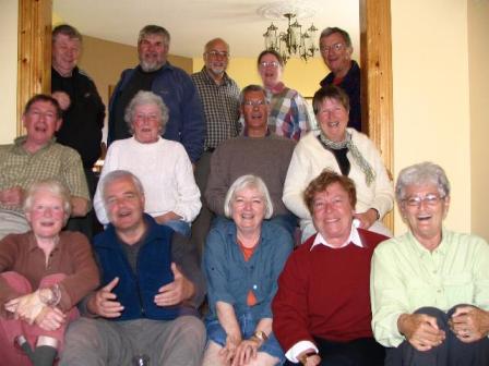
Click the photo of our friends above to see an album of Allihies photos. Close the window to return to this page.
We drove from Bantry to Castletownbere, the largest town on the Beara Peninsula. Liz and Yves Dat had just arrived via the ferry from France where they live on the Normandy coast. We drove to our Holiday Homes just outside the village of Allihies. Another nearby village, Eyeries with its gaily painted houses was the setting of a 1977 film, The Purple Taxi. Allihies houses are now painted in different colours and are equally pretty. We met up with the rest of our friends: Ginny and Huibert Arnold and Cathy and Bill Pawley from Ottawa, Claudia and Neil Carver from Waterloo, Sheila and Peter Talbot from Port Perry and Ginny and Jim Galway from Caledon at our rental houses. We had two large four-bedroom houses right next to each other. The houses couldn’t have been better. We had big kitchens to prepare communal suppers and large living rooms in which to gather. The first night we all gathered at O’Neil’s Pub in Allihies for dinner but most other nights we made our own meals. We took turns preparing a meal but we all had to meet the high standards set by the first dinner. Needless to say this was not a diet week. It was time to enjoy the company and renew our friendships. Claudia and Neil ensured we would all have lots of exercise during the day to work off our dinners. They suggested great hikes for all of us, mostly following portions of the multi-day Beara Trail. Up to ten of us set off for walks each day. The others visited many of the places of interest on the Beara Peninsula. We had no competition for the trails. The Beara Peninsula is not as heavily visited as Kerry or the Dingle but it meets or exceeds the views on the more popular routes. We had well-marked trails, spring flowers galore, great views of the rocky coastline, sheep in the fields, strange rock circles, standing stones and Ogham stones with inscriptions in a primitive Celtic writing system of slashes on the side of the stone. After one hike we rewarded ourselves with a visit to McCathy’s Bar in Castletownbere. The bar featured prominently in a very popular novel by the late Pete McCarthy in 2004. A highlight was our hike on Dursey Island. Only five permanent residents remain on this small island off the tip of the Beara. Most of the land is used for summer grazing of sheep and cattle and there are no shops, restaurants or accommodation. Access is by a cable car that runs high above the swirling channel waters. We hiked across fields to a Norman watchtower ruin then down to see the remains of a fort perched above cliffs on the tip of the island. The O’Sullivan clan ruled over much of Cork for centuries. One of their castles was on Dursey Island. The English captured Dunboy Castle, just outside Castletownbere, in 1602 so their leader Donal O’Sullivan sent 300 clan members to Dursey Castle for safekeeping. The Dursey Castle was captured as well and the entire population was butchered, many by being thrown over the cliffs into the sea. Donal O’Sullivan and 1000 of his followers spent the winter in Glengariff then decided to flee northward to Leitrim to join with other friendly clans. Their reception along the 300 mile trek was not as good as they had expected and the conditions were so difficult that only 35 people made it to Leitrim. This epic retreat was re-enacted in 2002 to celebrated the 400th Anniversary of the trek.
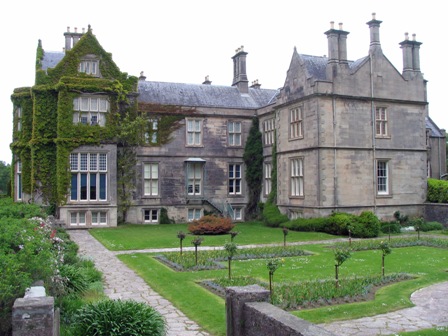
Click the photo of Kilarney Castle above to see an album of Southwest Ireland photos. Close the window to return to this page The week together with our friends came to an end and Ray and I were on our own again. That took a little getting used to as we had enjoyed the company of our friends. As well, the rains came more frequently. Instead of long walks we did a little more sightseeing and that was enjoyable. We drove to Killarney stopping in Kenmare for a walking tour of the town. There is another of those strange stone circles plus Our Lady’s Well, a beautiful flowered grotto. Pilgrimages have been made to this “holy well” from the time of the Druids and it became a place of secret worship after Cromwell banned Catholicism in Ireland. The Heritage Museum in Kenmare had very good displays on lace making begun as a money maker during the potato famine as well as a colourful history of the area. It was the weekend in Kilarney and the hostels were full. We stayed at Peacock Farm Hostal in the hills above Muckross. We had to stop and confirm we were on the right road as it was truly remote, but there was a great view from the hostel of Lough Guitane. The hostel was well named as the resident peacock kept trying to entice the peahen with his flamboyant display of tail feathers. She wasn’t interested. Our room, the only double in the hostel was booked for the next night so we moved into town to stay at Kilarney Railway Hostel. We had hoped to explore the area by foot but the rain clouds had moved in, so we set off in the car to drive the Ring of Kerry. After all the hype for this scenic wonder we concluded that the Beara Peninsula has as many or more to offer. The most impressive section for us was an extra loop not accessible to the big tour buses where we had good views of the jagged Skellig islands. To learn more about them we crossed to Valencia Island and visited the Skellig Center. We watched a video presentation on a monastery built in 600 AD on Skellig Michael, the largest rock. We wondered how anyone could survive on this sharply pointed barren rock. We would have loved to visit and climb the 600 stone steps to see the stone beehive huts that housed the monks but the seas were high and the crossing too dangerous that day. Sunshine greeted us the next morning, just in time for a hike up Torc Mountain. The Lonely Planet guidebook marked the trail as straight up the hill but the Parks people had been busy in the last three years. Switchbacks and sleepers (railway ties) steps interspersed with gravel paths made the 1 ½ hour climb up a little easier and safer for the environment. We had a great 360° view of the upper lakes and Muckross and Lough Leane. It looked so pretty below of the Muckross estate that we went for a tour in the afternoon. The wealthy Herbert family built the Manor house in 1843. Their claim to fame was a visit by Queen Victoria and an entourage of 100. They had two years to prepare for her visit so they redecorated the house from top to bottom. The Queen stayed just one night. Unfortunately Prince Albert died shortly after the visit and Victoria went into mourning. The family expected to be given titles and lands as a reward for the Queens visit but they never materialised. Instead the expense of the visit bankrupted the family. Beware Royal visits! The house and grounds are now part of the Killarney National Park. We passed several horse drawn “jaunting cars” taking people for a tour of the property. The gardens were in full bloom. The Rhododendrons towered over us and the rock gardens and water-gardens were impressive. Rhododendrons lined the roadsides wherever we drove but they are becoming a nuisance. Like many other introduced plants, Rhodos are taking over and choking out other native plants. They are beautiful anyway. There are advantages to staying in the tourist centres like Killarney and one is traditional music played in at least one pub every night. Our big problem up until now was staying up late enough to take in a session that started after 9:30 PM. Once we experienced our first session in Murphy’s Pub in Killarney we were hooked and searched out the best pub in other towns. The Dingle Peninsula came with rave reviews, so over we drove in the mist and drizzle. We stayed in a small hostel in a private home where we were entertained and vice versa, by five year old Mollie. We came away impressed by her intelligence and/or the Irish school system as she was far ahead of our Canadian kindergarten level children in her math skills and reading and writing in both Irish and English. Signs in many of the Dingle stores proclaimed that the town had been denied they democratic rights. It was shades of the French-English language fight in Quebec. Dingle has been declared an Irish speaking area and therefore the town names have reverted to their original Irish names and all but a few road signs are in Irish. The problem is that most road maps do not have the Irish names and tourists are continually getting lost. We had been unable to locate a hostel on our map because the new name bears no resemblance to the old name. Several of the roads signs leading to “An Daingean” are spray painted with the more commonly known name “Dingle”. A drive around the Dingle peninsula is a must. There is a rugged coastline around Slea Head, numerous ruins of forts, beehive stone houses and old churches to visit plus the interesting Blasket Center. The Blasket Islands are small rocky outcrops 5 km out in the Atlantic. The isolation of the people led to the retention of their unique Irish language and culture but the community is no longer there. Successive emigrations had reduced the population and there were no schools or medical facilities. After at least 300 years of habitation the last 27 people were moved to the mainland in 1953. Doolin, on the West Coast in Co. Clare had two draws. It is a center of Celtic music and ferries leave from the small port for the Aran Islands. We got to hear lots of traditional music but the Aran Islands will have to wait for another visit. The weather conspired against us. Winds of up to 100 km per hour stopped the ferries running for three days. We explored the Burren, the most extensive karst limestone region in Ireland, instead. Once covered by the ocean millions of years ago the ocean floor was built up over the ages with the remains of coral, shells and sand creating hard stone. The buckling of the earth’s crust forced the seabed above the water and bent and fractured the stone creating deep fissures. At first glance the area appears to be barren but wild flowers abound growing in small pockets of earth in the fissures. Blue Gentians, wild orchids, Purple Cranesbill and hundreds of other varieties add colour to the grey rock. Our host Mattie at the Rainbow Hostel showed us slides of the area and lent us maps for our drive around the area. We had tea at the Tea Junction in Ballyvaughan, a small harbour on Galway Bay and returned later for great seafood soup at Monk’s Bar. We visited Corcomroe Abbey ruins where a stone effigy of Conor O’Brien, who died nearby in 1267, lies. He was an Irish chieftain and patron of the abbey. We visited the popular Poulnabrone Dolmen Portal Tomb, similar to the one we had seen on the way to Wicklow. Thirty-three bodies were found inside the Poulnabrone Tomb, which dates from 5000 years ago. We never did find the Gleninsheen Wedge Tomb, made famous by the discovery in 1930 of a gold torque that hung around the neck of some ancient king. Family of the man who found the torque had sold the property and the new owner had removed all signs to discourage visitors. We passed by several castle ruins and visited the churchyard of the 12th C Kilfenora Cathedral, the smallest cathedral in the Ireland. Kilfenora is noted for its high stone crosses all intricately carved. Our hostel was just doors away from two pubs that featured traditional music every evening. We visited both, enjoying the music played on guitars, tin whistles, fiddles, the bodhran drum, concertina and the strangest one for me, the “small pipes”. The uillean is a bagpipe-type instrument played with the bag under an arm. A treat for us was a concert to raise money for the Doolin Music School. It was so popular that it was held in both the community center and a local church with the musicians moving between the two venues. We heard several well-rehearsed youth groups plus the best of the local musicians. The church we attended was quite cold so after two hours we left at 9:30 PM. We were told the musicians played until midnight. Since we couldn’t visit the Aran Islands, we made a detour to Ennis, another traditional music center. A stop to visit the Cliffs of Mohr was essential. We had passed the cliffs on the way to Doolin several days before but at that time they were shrouded in heavy fog, but the winds were blowing the clouds away on our second visit. A brand new visitor center and wide boulevards along the cliff tops spreads the crowds out. They were impressive. We visited an interesting Abbey in Ennis but the music, or lack of it proved disappointing. We heard only the last two numbers from a group who packed up and left at 9 PM, to be followed by a DJ. No traditional music was to be found on Saturday night in Ennis. If we had been there the following week we could have attended the annual folk music festival but we were too early. We returned to the Burren. We stayed in the village of Corofin where the manager, Mary, suggested a walk to Mullaghmore Mountain. Mary lent us a map that we needed as the trails we unmarked. The approach was over the rocky Burren, which we found out is difficult to walk on. You have to continually watch your step or risk twisting an ankle in one of the fissures. We climbed a series of 10 m high rock walls to the top where the open landscape allowed us to see far away in every direction. That evening we went to the local pub for a pint before making our dinner in the hostel. A group of locals were celebrating the first communion of several of the children. Several young girls were in long white dresses and a few boys were in their Sunday best. The long dresses didn’t hamper the girls ability to dance. It was mothers and daughters only, some as young as 3 or 4 years old, having a grand time dancing to a DJ’s tunes. The men were belly up to the bar but some of the young boys looked as if they would have loved to join the girls. The DJ started into a traditional number and three of the girls got up and showed us how to do a proper Irish dance. They were very good. We only had a few more nights in Ireland so we decided to return to Doolin for one last night of music, but first we had another hike to do. The ruins of Oughtmama churches and Turlough Hill, near Ballyvaughan sounded interesting., so off we headed. We stopped at a house advertising guided walks in Oughtmama and asked directions to get to Turlough Hill. The guide, John, told us that all the land was private property but that if we joined his hike, he would let us know when we could divert and get to the top of the hill. John had two women already there but he was waiting for a tour bus originating in Galway to deliver a group who would join us. When the group arrived we set off up a hill while John gave us a running commentary of the geology and history of the area. We left the group after almost an hour and followed John’s directions to Turlough Hill. The Oughtmama valley is green grazing territory for cattle in the summer but in the winter the farmers graze the cattle on the top of Turlough Hill. Turlough is from the Irish meaning disappearing lake. They flood in the winter, keeping the meadows green. Sure enough we found meadows and not bare rock on the top of the hill. There are also the remains of a stone-aged fort and huge burial cairns on the top so there was much to distract us on the way. Back in the Oughtmama Valley we walked around the ruins of three small 12th C chapels built by monks in search of a quiet life. After attending our last music session in the Doolin pubs we drove to Shannon where we stayed in a B&B prior to flying back to Canada. The B&B was pleasant but the “purpose built” town of Shannon is the only place in Ireland with a modern shopping mall as the town center and even that shuts down after 5 PM. We were lucky to find at least one place open for supper. So ended our visit to the Republic of Ireland. There are still plenty of places we didn’t visit and more walks to do, so I am sure we will visit again some day. |
Return to Europe Intro
Return to Travels
Return to Introduction