|
|
|
|
Read Previous Episode Queenstown to Invercargill
Episode 7: Page 2 of 2 Mt Somers to Christchurch
| Wednesday 27
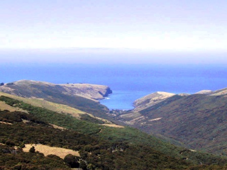
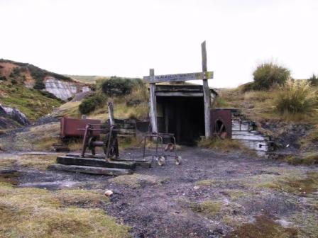
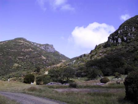
February 2002, Christchurch NZ Wild Things and Farewells Continued from Episode 7: Page 1 Catlins to Mt Cook We planned to be in Christchurch for Thursday 21 February to give us time to advertise and sell Alice. It was only Tuesday when we left Mt Cook, so we had time for another overnight hike. The Lonely Planet Tramping in NZ book detailed an interesting tramp called the Mt Somers Sub-alpine Walkway, and it was on the was to Christchurch. Lake Pukaki is the terminus of the glacial valley of the Mt Cook area. We took the scenic route almost all around the lake before heading east again. That gave us more time to soak up the scenery before leaving the Southern Alps. It was warm and sunny when we stopped for lunch at Lake Tekapo, just east of Pukaki, but we could see ominous looking clouds in the direction we were heading. Sure enough we ran into rain that got heavier as we went over the mountains at Burke's Pass. This is typical of NZ. With such varying topography in such a relatively small area, the weather can change rapidly. It rained all that evening, but the forecast was for clearing, so we went ahead with our tramping plans. The Mt Somers Sub-alpine Walkway is not a loop walk so transportation is needed to get to the trailhead and back again. When we reached the village of Staverly, the finishing point of the hike, we were met by a local woman who drove us to the trail head in our car, then she drove Alice back to her own home where it would be safe until our return. We set off, following an old trail used by coal miners to reach the mines about an hour's walk through a black beech tree forest up the mountain. There are two huts on the trail. The walkway to the first hut and the Mt Somers hut are maintained by a local organization. It is a popular walk on the weekends, but there were hardly any other people around for our mid-week walk. The mines have been closed since 1968 but one of the mine entrances has been restored as a reminder of the former industry. A rail line had been constructed to send full coal cars hurtling down the mountain to be transported out of the area. Parts of the rail line and a few rusting coal cars had been left next to the trail. It must have been a tough life.
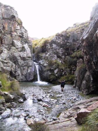
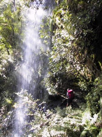
We had a picnic lunch at Mt Somers hut and continued on up to another ridge. To the west we could see the fertile Canterbury plains just beyond the end of the mountain range we were in. We came to a rocky cliff with a waterfall coming down to a stream. I crossed the stream and stopped to take some photos. Just then, I heard the sound of rocks falling. Just on the other side of the stream sat a possum, calmly sitting and washing himself. We wouldn't have noticed him if he had not tripped over the rocks. I thought possums only came out at night, but this one plainly liked the sunshine.
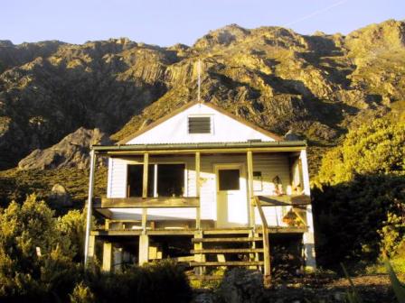
We continued on to Pinnacles Hut, a newer and larger hut maintained by DOC. A young American couple, who had stayed the previous night in Mt Somers hut, was already there. They told us that if we had gone far enough down the stream near Mt Somers hut, we would have discovered a rustic, but working sauna. They had read about it in the log book left in the hut and had built a wood fire to heat the stones, then jumped into the ice waters of the stream to cool off. The four of us had the place to ourselves for the night. We were glad to have a small wood stove to keep us warm at night as the temperature drops in the mountains after the sun is down.
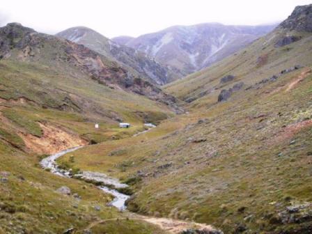
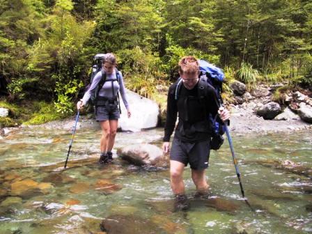
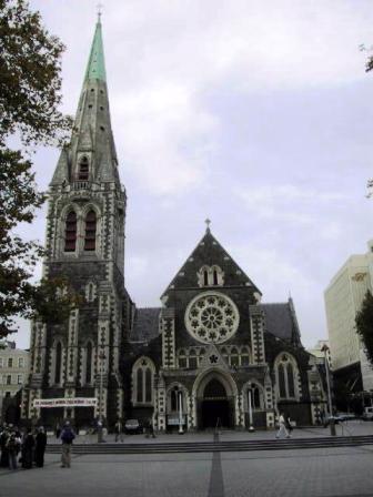
The trail the next day was more difficult than the first day. It made its way down through a beech forest across numerous small streams. Most of the streams were easy to cross on the stones, but we had to ford one. We took our boots off and crossed in our bare feet. The water was freezing and I had to thaw out my feet on the other side before continuing on. The American couple reached the stream just as we were getting our boots back on. They have caught the Kiwi spirit and just marched across in their boots. I still don't like hiking in wet boots. We followed the main stream for a while then climbed up a muddy hill side track to Dukes Knob, where we had a small lookout to see where we had actually been that day. We could just make out the pass in the dense forest. From there it was downhill again to a parking lot for people starting the tramp from that end. We stopped to talk to three local women who had just completed a day walk. They offered us a ride back to town and we were glad to accept. That was a better option than an extra half-hour walk back to town. We said goodbye to the women and went to pick up Alice. Our shuttle driver, Jan Crozier, is certainly a busy lady. She runs a B&B, sometimes providing all meals, maintains a beautiful garden and somehow fits in shuttle services for trampers. When we arrived, she was saying goodbye to a friend who had dropped in with two Japanese visitors. She was just about to give them a garden tour, so we were invited to join them. She had several acres of perennials, hydrangeas of every hue, beautiful roses and many varieties of lavender. It is good enough to be included in an upcoming garden tour. In the back of her house she had a grass tennis court. She was not very pleased with the state of the court though. A local firm had redone the surface recently and had not done a very good job. She was waiting for them to return to rip it up and start again. What a lot of work. I prefer clay courts myself. We collected Alice and drove on to Christchurch. We lucked out with our hostel in Christchurch. The Vagabond Hostel also has a two-bedroom flat next door, which we shared with one other couple. It had its own kitchen, living room and bathroom. We spent the rest of the afternoon bringing our hand-made posters advertising Alice for sale to all the hostels in Christchurch. There were lots of similar ads already displayed, so we hoped we wouldn't have too much trouble. Two German fellows were looking over the ads in one hostel, so we asked them if they would be interested in Alice. They came over that evening to have a look but they really wanted a station wagon. While they were inspecting the car, a call came in asking if we could bring Alice over to another hostel for a prospective buyer. When we drove over, there were two Israeli girls going through the ads for cars. They had a brief look at Alice before the people who had phoned us arrived. The callers didn't want to meet our price, so when the Israeli girls phoned back the next morning still interested in Alice, she was available. They wanted a mechanical inspection done, so that was arranged. The inspection did not reveal anything we did not already know, but the girls were reassured they had a road-worthy car. We agreed to a price and the deal was done. Alice had a new home and we had ended up with very cheap transportation for our NZ trip. We were both happy. We were doubly glad we had sold Alice when we did because all the posters I had made had the Vagabond phone number on it. The phone proceeded to go out of order that day. First, outgoing calls didn't work, then incoming calls got cut off. Next time we would arrange to get a cell phone to use when we have a car to sell.
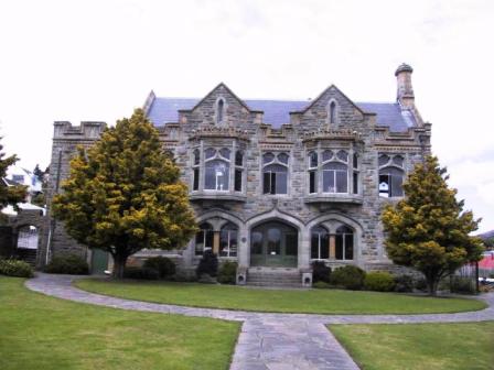
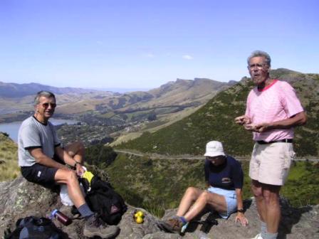
Celia and Beattie Mackenzie stay about 30 K away from Christchurch and offered to show us some of the area. They came in for dinner with us on Friday evening, then came and picked us up on Saturday to go for a walk in the Cashmere Hills overlooking Christchurch. At the turn of the century a wealthy local resident Harry Ells built a series of trails and shelters for local walkers. The shelters are much more elaborate than the huts DOC maintains. He envisioned them as comfortable tea houses, built of stone and named them after NZ birds. The last one he built, the Sign of the Takahe, is the size of a small castle and is now a fancy restaurant surrounded by lovely gardens. Beattie and Celia said they were guests at a wedding there. The Sign of the Tekahe is at the top of a steep winding road that is a favourite hill climb for bicyclists. There is also an annual race up that goes up the road and continues all the way to the Bank's Peninsula, 100 K. We passed several bicyclist struggling up the hill on our way to the start of our walk. We had a good hike up to the top of a hill overlooking Christchurch harbour on one side and Governor's Bay and Lyttleton Harbour on the other. The next day we took the Shuttle bus to Akaroa on the Bank's Peninsula. Our first idea had been to do the Bank's Peninsula Walk, a two to four day privately run walk. We couldn't get a reservation so we booked a room in a hostel in town and prepared to do day walks. It worked out very well. The Bank's Peninsula is a collapsed volcano that has left a long bay to the ocean surrounded by hills. Akaroa was a delightful little town full of restaurants and shops near the end of the bay. We even sampled a few of their restaurants, a change from making our own meals these last few months. Akaroa was settled by a group of French colonists in the mid-1800s and still retains a little of its French roots in the street names. It is a tourist favourite but was nice and laid back when we visited.
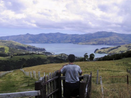
We had beautiful sunny weather for our day hikes. The first afternoon we walked up well-marked paths to Heritage Park on a peak 350 M above the town. The second day we walked up even higher. We followed the route for the last day of the Bank's Peninsula Walk then continued up to the Stony Bay peak nearly 800 M above the town. Both spots had a great view of the bay and surrounding countryside. We were sure we could even see the snowy peaks of Mt Cook National Park from the top. Our last day in Akaroa was a little cool and overcast, but still good enough for a kayak trip on the bay. There are Hector's dolphins in the area and we wanted to see them close up. We had investigated the various companies offering 'swim with dolphins' experiences but concluded that a double kayak would fit our bill. Tuesday morning we arranged for a half day rental, dressed in the spray skirts and life jackets provided, found out where the dolphins were likely to be and set off. Just as we passed the small community of Onuku, about 1-½ hours later, we spotted our first dolphins. There were three of them, swimming in unison just a little further into the channel. We headed that way and searched for the familiar fins arching above the water. They were still around. We floated where we were for a while watching them come even closer to us. A few times they were close enough for us to hear them blow and once they dove right beside the kayak. We watched their silver bodies streak by just under the surface. When it seemed that they were tired of investigating us, we both moved on. There was another group of kayakers and a boat full of wet-suited customers closer to the mouth of the bay. That was a sure sign of more dolphins, so we paddled in their direction. Sure enough there were several more dolphins playing around the boat. We stayed out of their way and watched one swimmer get into the water and float around waiting for a swimming companion. I'm not sure if he had a fish as enticement, but he was visited quite closely by a few of the dolphins. It looked as if the dolphins were moving away, so we decided it was time for us to return to town. It was a well spent four hours and a fitting end to our wild life experiences. We returned to Christchurch in the afternoon and checked back into the flat at the Vagabond Hostel. The weather is still pleasant, just right for our last explorations of Christchurch before we take the plane home tomorrow afternoon.
We have done a lot and seen much of NZ on this trip, but there are lots of places left for a future visit. If you like the outdoors and beautiful scenery, this is the place to visit. We have enjoyed ourselves greatly. But now it is time to leave. We will be making plans for another trip somewhere next year, but at this time we don't know where that will be. There are so many places to go and so much to see. With the political situation as it is in Nepal, I'm afraid we will not be able to return there for a few more years. In the meantime we look forward to seeing all our friends back home. |
Back to: Episode 7: Page 1 Catlins to Mt Cook
Read about our visits to the Cook Islands or Fiji
Return to New Zealand Intro
Return to Travels
Return to Introduction