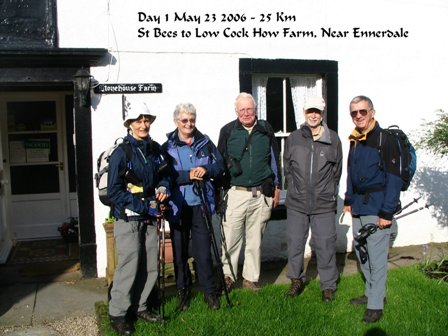
Click the photo of our group starting the hike to see an album of photos. To return to our website close the window.
| Oh, to be in England
now that Spring is here. It is a glorious season to
explore the English countryside. Everything is lush and
green, the flowers are in full bloom and the lambs gambol
in the fields. And what better way to get close to nature
than to go for a walk. At least that is what we thought
and we were right. Five friends from Ottawa walked 190
miles (over 300 Km) across the northern part of England
and loved it. We were very proud of
ourselves when we finished, suffering no more that a few
minor blisters. With all the good beer in the pubs and
huge English breakfasts we didn’t lose any weight
but we finished our walk healthy and happy and would
recommend the walk to anyone who is reasonably fit and
can walk four to eight hours a day. Alfred Wainwright (1907-1991) was a veteran walker in England who was tired of the traditional but boring walks he had completed. He wanted a walk of several days length that would be both scenic and challenging but still accessible to the relatively fit walker. In 1972 he published a small guidebook with a detailed description, including hand drawn maps and sketches, of a 190 mile walk from St Bees Head on the Irish Sea to Robin Hood’s Bay on the North Sea, passing through three National Parks along the way. Wainwright proposed that the walk could be accomplished in 12 days of walking, staying in small villages overnight. Barb Wilson was retiring from her job in the Library of Parliament in May. This was to be her retirement celebration but she wanted some companions for the trip. Many of us who are regular walkers have heard of this legendary walk across England. Barb’s husband Don, Morris Davison, Ray and I thought this would be a great way to see England. Barb did most of the research for us and found out that there was now a van service to carry your overnight bags from village to village and we could avoid several of the long hiking days suggested by Wainwright. Instead of 12 days, we would walk for 17 days and since none of us had a tight schedule, we added in two extra rest days to do laundry and explore more of the countryside. It was a great schedule. Sherpa Van, the company we chose to carry our bags, also made reservations for us in Bed and Breakfasts and pubs along the way. Our hosts were friendly and welcoming and the accommodations were first rate, a cut above the hostels Ray and I usually stay in. We were in no danger of going hungry. We eventually cut down on the offered full English breakfast. The most common breakfast consisted of fruit, cereal, toast, eggs, bacon, fried tomatoes and mushrooms, baked beans and even blood sausage. We bought packed lunches from either our hosts or from a local store, often the post office/mini-mart. Our evening meals were in the local pubs but occasionally we arranged to have our evening meal provided by our hosts. These meals were a special treat. You can understand why we didn’t lose weight! Thursday night, May 18, 2006 we flew on Air Canada to Heathrow. We would start our walk from St Bees the following Tuesday so that left us time to get over jet lag. Morris left us to visit a friend in London and the rest of us took a British Midland connecting flight to Manchester. In Manchester we signed up for an excellent walking tour of the Victorian center with a retired British Telecom engineer. Manchester is known for its wet climate and it was true to its reputation. We experienced Manchester in the Mist. The wet climate was responsible for Manchester becoming the largest cotton-weaving center in the world in the 19th C. Cotton fibres don’t break easily in a damp climate so cotton was shipped from all over the world to be woven into fabric. Unfortunately this prosperity didn’t last. Competition from US and Europe combined with the lack of modernization in the plants wiped out the industry. The city’s next attempt was to become a major port. A canal was built in 1894 beside the Mersey River from Liverpool, 55 miles (88 Km) away, to Manchester. As ships got bigger the canal was used less and less for shipping and Manchester went into another decline. In the last 20-30 years the city has been revitalized, partly due to the growth of the technical and engineering faculties of the University of Manchester. Buildings have been cleaned of the grime from the smoke and smog of defunct industries and WWII damage has been repaired. We were impressed. We took a train from Manchester to Whitehaven and then a taxi to St Bees, where Morris would join us in time to start our walk. In the meantime we had an extra day to explore. The weather was still cold and rainy but we went for a walk anyway. We met a few hardy souls on the trail who were starting out on the walk in miserable weather. We were glad we could wait for another day with better weather. We explored a 12th C church in town that displayed the remains of a knight found on the church grounds during renovations. His body, buried in a lead-lined coffin before the main church was even built, was perfectly preserved. That evening we ate in a pub and listened to local folk singers gathered for their weekly jam session. The next day was much improved and with Morris back in our group we started out. We followed the tradition of wetting our boots in the Irish Sea and taking a small stone from the beach to be carried in our daypacks all the way to the North Sea. The route started around a headland with the Isle of Man just barely glimpsed through the mist off the coast. A large colony of sea birds nested in the cliffs at one point along our route. That first day several patterns were established. Facilities are few and far between on the trail. Most of the time we were hiking through rural countryside with just the occasional farmhouse or village before reaching our evening destination. We ate a packed lunch along the trail in some scenic spot. There were lots of sheep pastures to cross and there was sure to be at least one hill to climb with views from the top. We met other hikers and walked along with them companionably but it was never crowded. We covered about 12 miles (20 Km) each day, sometimes more, sometimes less. We took full advantage of our detailed maps and the good description of the route in Wainwright’s book, plus consulted our compass and Don’s GPS that he had programmed for the route. Nevertheless, we sometimes “explored extra trails”, meaning we missed a turn, but we never got completely lost. Most days the weather co-operated. We were told to bring full rain gear and it was good advice. We were actually very lucky with the weather. It had been cold and wet for a few weeks before we started our hike and England ended up in a heat wave after we finished, but we experienced neither of those extremes. The winds come from the west and once they hit the Cumbrian Mountains, they drop their moisture, but the rain was never heavy and didn’t last all day. Tops of hills tended to be windy and cool but by the time we reached the valleys the sun came out and our jackets were stowed in our backpacks once again. Morris assured us that once we passed the Pennines, the weather would be much better. In fact it improved even before then and we were soon slapping on the sunscreen every day. The second day brought us into the Lake District National Park. Ray couldn’t get over the wildness of the terrain. We were climbing up 2000-3000 ft on bare craggy paths to peaks and ridges looking down on long narrow lakes in the distance. When Wainwright died, his wife and son scattered his ashes in one of the mountain tarns near the trail. The landscape reminded us of the White Mountains of New Hampshire. We planned our first rest day in Patterdale, in Wordsworth country next to Ullswater Lake. To get there from Grasmere we planned to take two alternate steeper trails, but for once the weather conspired against us. The fog and mist were so heavy we missed a turn and found ourselves climbing up the first alternate route. The views were reputed to be fantastic but we could only take their word for it as we couldn’t see a thing. We were walking along the path when we realized that strange sound we had been hearing was the lapping of water in Grisdale Tarn, a small mountain lake no more than a meter from the path. The weather continued on cool and wet until we reached the brow of the hills and in the distance we saw sunlight. It was all sunny and warm by the time we reached Patterdale. We stayed in the White Lion Pub in Patterdale. An elderly woman from the village had passed away that week. Her many friends and relatives held a wake the afternoon we arrived in the pub. By the evening the mood was merry and the guests broke out in song, “When the Old Man Died”. We managed to find a space near the dartboard and Morris insisted we play a game. We were terrible and we didn’t really improve but we had fun. We just had to make sure no one was close enough to be hit by one of our wild throws. In another pub we discovered Dominos, a good game to amuse us in the evening. A day after leaving Patterdale we were out of the high hills of the Lake District and into the Yorkshire Dales National Park. This didn’t mean the end of hills however, it just meant they weren’t quite as high. Limestone was everywhere, explaining why there were so many old stone barns and miles and miles of expertly built stone fences. Moors covered in heather, not yet in bloom, spread out over the hills. We were thankful of waterproof hiking boots crossing the mossy, boggy tops of the dales. Morris was our Canary of the Bogs. We would watch where he crossed a particularly wet area and decide whether to follow him or not. That way we managed to avoid soakers. We crossed the Pennine Way, another famous walking trail that runs north and south, at the half-way point in our hike. We took an extra loop in this area to see the remains of iron mines that were active from Roman times and hit their prime in the 17th and 18th Century. Miners would dam up rivers high in the hills and release their waters suddenly to expose iron deposits. By the end of the 19th Century the best veins were depleted and cheap foreign imports supplied the market, causing the mines to be abandoned. Richmond, a traditional market town with an 11th Century castle, was our second rest day. Saturday is market day in the historic cobbled center of town, albeit not the busiest we have seen. We managed to buy cheeses, olives, bread and wine for a sumptuous picnic in a popular park beside the pretty River Swale. We also toured Richmond Castle, begun in 1071 by Alan Rufus, a kinsman of William the Conqueror. He chose his site high on a hill overlooking the river and named the town “Riche-mont”, meaning Strong Hill. The next few days were a change in scenery. The land was relatively flat, with fields of well advanced crops. England has a well-entrenched tradition of walking paths, that was most impressive. Farmers are required to keep clear any footpaths that have traditionally been used to get from town to town. Several fields had a carefully mowed path around the outside or right across the middle. Soon we were crossing our third national park, the North York Moors. The first section shared the same route as another famous walking trail, the Cleveland Way. Many of the paths were paved with stone to protect the fragile sub-surface. We followed one stretch of straight stone road over barren hills for 17 miles without seeing any trees. There are not many B&Bs in this area so Sherpa Van booked us into Great Broughton, a two-mile diversion from the trail. There we stayed with Margaret and Len Suttcliffe, a couple of octogenarians. We sat in the sun in their beautifully tended garden while Margaret served us cookies and tea and Len finished up his Spring planting. Their daughter, who lives next door, arrived in the morning with her two small boys to help prepare a box lunch for our journey. We were sad to bid them all goodbye. Our overnight stops depended on the proximity of towns. Our more relaxed schedule gave us one short 10-mile day in Yorkshire. We took advantage of this to take a side trip on a steam train. Grosmont, just 1 ½ miles from our overnight stay in Egton Bridge, is the center of the North York Moors Railway Society. Steam locomotives from all over Britain are sent to the rail yards in Grosmont for maintenance. You can visit the yard, which is heavily dependent on volunteers, to see various steam engines undergo repairs. Several movies featuring steam trains have been shot here, including at least one of the Harry Potter series. A popular tourist attraction is to take a ride on the steam train on its route between Pickering and Whitby. We bought tickets for a short fifteen-minute ride to Goathland, AKA Aldensfield, which has turned into a major tourist attraction due to the popularity of the British TV series Heatbeat. We had time to walk past Scripps Garage, window shop and have lunch in the Aldensfield Arms before riding the steam train back to Grosmont and resuming our hike. Nineteen days after starting our hike in St Bees, we reached the North Sea and followed the cliff-top trail into the village of Robin Hood’s Bay. Robin Hood’s Bay is a busy tourist town built on two levels. Our B&Bs were in the newer upper level and the original fishing village is 100 M lower, next to the sea below the cliffs. We headed straight down to the small harbour at the bottom of town, the official end of our walk. We dipped our boots into the water and threw our Irish Sea pebbles into the North Sea. We congratulated ourselves as we had done it all and were all in excellent shape. An extra bonus for us was to find we had arrived in Robin Hood’s Bay on their annual Folk Festival Weekend. Groups, both amateur and professional, gave free concerts outdoors during the day and in several of the pubs at night. Barb was pleased when a participant lent her a Bodhran, an Irish drum, which she played for a few numbers. Of course the perfect accompaniment to the music is a pint of beer, so we soon felt right at home. The next day we parted company with Don and Barb. They were going first to Whitby, then joining friends for several days before returning to Canada. Morris, Ray and I took a taxi to Scarborough, where we took a train to York. Morris continued on to London while Ray and I spent our last days in England exploring York. In York we visited the famous Minster, St Peter’s Cathedral. The first church was begun in the 7th century; the present one, completed in 1472, is the fourth on the site. We took a free walking tour to learn more about the city. The walls that encircle the old city were first built by the Romans and enhanced in Medieval times. Four main fortified gates, the Bars, protect the entrances to the old city. Thanks to the foresightedness of a Victorian era man who persuaded the city leaders not to destroy the walls in the name of progress. Instead, the ramparts were extended and the two-mile wall walk became a “must-do” activity for tourists, including us. We walked along Shambles street, lined with half-timbered houses. The name “Shambles” comes from the Saxon “Fleshammels” meaning the booths and tables the butchers on this street displayed their meats. Our trip ended on June 13, 2006 when we took a train to Manchester airport where we flew to London and rejoined Morris for our flight home to Ottawa. It was a great trip and a great hike. We now understand why it has become such a popular route with its great scenery, comfortable lodgings and good beer and food. Where are we going to walk next? Who knows! There are so many places in the world to explore. AppendixThere are companies who will arrange the whole trip for you but it is very easy to walk independently. You can carry your own bag but we found the van service well worth the added expense. Check out the website for the van and accommodation service we used. It has lots of informative links. The British prices are also listed on Sherpa Van The following website is useful in determining your itinerary for the Coast to Coast Walk: Contours.co.uk We recommend a combination of one of the following books describing the walk plus a detailed set of maps. We used Wainwright’s book, 2004 edition and the Harvey Maps. Don used these maps to plot GPS points. A compass is very useful to make sure you are going in the right direction. A Coast to Coast Walk – A Pictorial Guide
by Alfred Wainwright at
Indigo-Chapters Books Coast to Coast Path by Henry Stedman (Aug 2004
) is also available from
Indigo-Chapters Books A Northern Coast to Coast Walk by Terry
Marsh from
Amazon Canada Maps: Harvey Maps 1:40,000 2 maps: Coast to
Coast (East) and Coast to Coast (West) from
Amazon Canada Maps |
Return to Hiking
Return to Europe Intro
Return to Travels
Return to Introduction